Daeareg
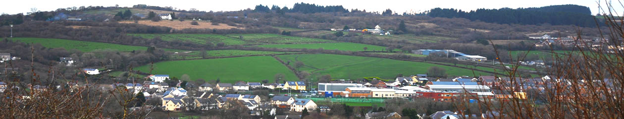
Mae daeareg yr ardal wedi bod yn greiddol yn ffurfiad tirweddol a chymunedau cyfredol Gorslas. Mae dwy afon Afon Gwendraeth Fawr ac Afon Gwendraeth Fach yn llifo o’r dwyrain i’r gorllewin drwy galon Sir Gâr. Mae ardal Cyngor Cymuned Gorslas wedi’i osod o fewn dyffryn Afon Gwendraeth Fawr sydd yn ffinio i’r gogledd-orllewin gan gefnen o graig caled unionsyth (calchfaen carboniferaidd a gritfaen) gan gynnwys Mynydd-y-Garreg a Mynydd Llangyndeyrn. I’r de-ddwyrain o ddyffryn yr Afon Gwendraeth Fawr mae cefnen Mynydd Mawr, Mynydd Sylen a Mynydd Penbre sy’n gyfoeth o waddodion glo a haearn.
Mae’r gefnen ogleddol wedi ei fwyngloddio am galch a charreg silica ers sawl canrif, gyda chalchfaen yn cael ei losgi mewn odynau a adeiladwyd yn y chwareli er mwyn cynhyrchu calch i wrteithio’r tir. Achosodd y tollau a godwyd i gludo’r calch yma ar ffyrdd tyrpeg yn ystod y 1830au gryn dipyn o anghydfod a thanio Terfysgoedd Becca yn 1839, gan arwain at chwalu’r tollbyrth a’r tollfarau. Yn ôl hanesion lleol, ceidwad tollborth cyfrwys a achubodd dollfar Drefach rhag ei difrodi wedi iddo weld Rebecca a’i ‘merched’ yn agosau ar garlam drwy ei ffenestr arsyllu, a mynd ati i godi’r bar iddynt basio’n ddi-drafferth.

Adleolwyd y dollfar ym Mharc Cymunedol Drefach yn y 1990au, a hon yw’r unig dollfar o’i bath yng Nghymru. Fe’i hadeiladwyd ar ffurf tŷ bychan gyda’r bwriad o lochesu un toll-geidwad.
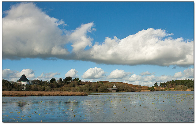
Mae afon Gwendraeth Fawr yn tarddu yn Llyn Llech Owain, i’r Gogledd o bentref Gorslas ac o fewn pellter cerdded i barc cymunedol Gorslas. Mae Llyn Llech Owain yn Safle o Ddiddordeb Gwyddonol Arbennig (SoDdGA) ac yn Barc Gwledig dan reolaeth Cyngor Sir Gâr. Mae’r llyn a’r fawnog sy’n ei amgylchynnu yn gynefin prin yn yr ystyr ei fod yn gynefin sydd yn iseldir (250 metr) ond sy’n meddu ar nodweddion ucheldir.
Mae llwybr wreiddiol yr afon rhwng Llyn Llech Owain a Cwm Mawr yn anodd i’w ganfod a hynny yn sgil yr holl wedd-newid a achoswyd gan gloddio brig a gweithgareddau diwydiannol eraill. Roedd llawer o’r tir hwn yn dir comin. Roedd comin Mynydd Mawr yn ymestyn dros 5000 acer ac yn rostir agored o ansawdd amaethyddol gwael a ddefnyddid fel tir pori yn ystod misoedd yr haf.
Wedi amgau y rhostiroedd hyn yn sgil deddfau seneddol yn y bedwaredd ganrif ar bymtheg, ffurfiwyd patrymau hirsgwar o gaeau ag iddynt ffiniau sythach nag a welid mewn ardaloedd ymhellach i’r gorllewin a’r gogledd. Mae’r patrymau hyn o gaeau hirsgwar yn nodweddiadol o goetgaeau, a than yn ddiweddar roeddent i’w gweld yn glir yn y caeau rhwng Gorslas a Chefneithin.
Mewn gwrthygyferbyniad, mae Afon Gwendraeth Fach, sydd i’r Gogledd-Orllewin o’r gefnen galchfaen, yn llifo dros diroedd tywodfaen cochlyd ffrwythlon. Dyma ardal ag iddi gaeau o siapiau afreolaidd, ffermydd gwasgaredig
Geology
The geology of the area has been fundamental in shaping the landscape and communities which now exist in Gorslas. Two rivers, Gwendraeth Fach and Gwendraeth Fawr, flow approximately east to west through the heart of Carmarthenshire. The Gorslas Community Council area is set within the Gwendraeth Fawr valley which is bounded to the northwest by an upstanding ridge of hard rock (carboniferous limestone and millstone grit) including Mynyddygarreg and Mynydd Llangynderyn. To the southeast of the Gwendraeth Fawr is the ridge including Mynydd Mawr, Mynydd Sylen and Pembrey Mountain which is rich in coal and iron deposits.
The northern ridge has been quarried for both lime and silica stone for many centuries with limestone being burned in kilns built at the quarries – to produce lime to fertilise the land. The tolls charged to transport this lime on turnpike roads during the 1830s were a major issue that sparked the Rebecca Riots in 1839 and led to the smashing of tollgates and toll bars. According to local history, it was a shrewd toll keeper who saved Drefach Toll-Bar from damage by Rebecca by lifting the bar as soon as he spied Rebecca in his observation window.
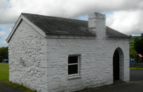
This toll-bar was re-sited at Drefach Community Park in the 1990s and is the only known toll-bar in Wales. It was built as a miniature house intended to shelter one toll-keeper.
The source of the Gwendraeth Fawr is at Llyn Llech Owain, north of Gorslas and within walking distance of the community park. Llyn Llech Owain is a Site of Special Scientific Interest (SSSI) and also a Country Park managed by Carmarthenshire County Council. The lake and surrounding peat bog represent a rare habitat in this area being an essentially upland habitat in a lowland area (250 metres).
The original river course is difficult to detect between Llyn Llech Owain and Cwmmawr due to the amount of past disturbance caused by open casting and other industrial activity. Much of this area was Common Land. Mynydd Mawr Common covered an area of approximately 5000 acres and was open moorland of poor agricultural quality which was used for summer pasturing.
Nineteenth century parliamentary enclosures of this open moorland resulted in a rectangular field pattern with straighter field boundaries than those in the countryside further west and north. This rectangular field pattern is typical of later enclosures and can be seen clearly in the fields between Gorslas and Cefneithin. By contrast The Gwendraeth Fach, which lies to the north west of the limestone ridge, overlies fertile red sandstone soils. This is a rural area with irregular field shapes, scattered farms and small villages. The more irregular field pattern is also in evidence west of Drefach as can be seen in long views form Drefach Community Park.
There are substantial areas of coniferous tree planting around both Mynydd Mawr Woodland Park and Llyn Llech Owain. Elsewhere in this part of the Gwendraeth valley woodland is largely limited to streamside trees and copses. There is more woodland on the ridges to both north and south, and to the west of Tumble and Drefach.
Much of the Gwendraeth Fawr is no longer classed as purely rural as it lies within the Carmarthenshire anthracite coalfield (which established Welsh coal as an internationally acclaimed fuel) and has been shaped by coal and iron mining together with industrial settlement. It has many characteristics of a typical coalfield district following the industrial scale exploitation of the late nineteenth century. By 1890 there were twenty deep mines operating between Cross Hands and Trimsaran with deep coal mining reaching its peak in the 1930s. However in contrast to the traditional concept of a mining area, farms have remained in close proximity to coal mining and the area has retained many rural characteristics.
The present day Mynydd Mawr Woodland Park, which is located north of Tumble and south of Drefach and Cefneithin, was the site of two collieries until the 1960s. The area was then opencast and the range of natural habitats now developing on the reclaimed site make up a patchwork which is clearly more recent in origin than the agricultural field pattern in other parts of the valley.
Large-scale coal production in Gwendraeth Fawr ended as recently as the 1990s by which time coal extraction was opencast rather than by deep mining. Most of the colliery complexes and tips have now gone following reclamation but the landscape is still clearly different in character to that of the Gwendraeth Fach.
Iron ore was also found in the coal measures, including that in ironstone beds located between Gorslas and Cefneithin. The iron ore was exploited by, among others, Alexander Raby – a Scottish industrialist who established an ironworks at Cwmddyche, Llanelli. Raby opened the Carmarthenshire Tram Road in 1802 which was the first public railway in the world and was used to transport iron ore, silica stone, and limestone. The line closed in the second half of the twentieth century and is still of considerable historic interest.
It is now a cycle-way forming part of the National Cycle Network – this part of Route 47 follows the railway track from Llanelli through Tumble and to a point south of Cefneithin before joining the road northwest through Foelgastell and Porthyrhyd. Route 47 provides a direct link from the area to the National Botanic Garden of Wales at Middleton Hall, Llanarthne. This is the first national botanic garden to be developed in the 21st century and is an attraction of international standing with its Great Glasshouse and conservation of some of the rarest plants in the world.